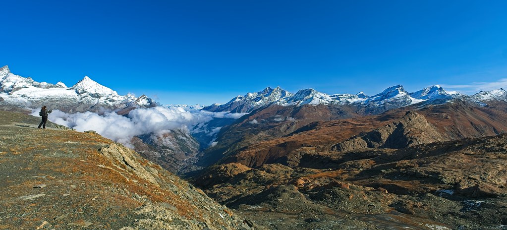
At the Mueller Hut in Aoraki/Mount Cook National Park, on the evening of April 22, the wind began to blow from the northwest at twenty knots at six o'clock. By eight it was forty. By ten it was sixty-five, gusting eighty, and the hut warden was on the radio with the Department of Conservation office in Twizel discussing whether the walkers planning the Sealy Tarns descent the next morning should consider waiting a day.
The wind that night was not the wind in the regional forecast. The regional forecast had called for moderate northwesterlies. The wind at Mueller was a foehn, accelerated by the geometry of the Mount Cook range, and it was doing what foehns do.
Trail walkers tend to learn the synoptic-scale winds first: the warm front, the cold front, the frontal squall. These are the winds the television forecast announces. The winds a walker actually meets are often local winds, produced by the interaction between the larger-scale flow and the shape of the ground.
Three local winds recur often enough on the trails of the temperate world to be worth knowing by name.
The first is the foehn (also called the Chinook in the Rockies, the Helm Wind in Cumbria, the Bora in the Adriatic, the Santa Ana in California). A foehn is the warm, dry, fast wind that descends the lee side of a mountain range when synoptic flow forces air over the crest. The air gives up its moisture on the windward side, then warms adiabatically as it descends, arriving in the lee valley significantly hotter and drier than the air on the upwind side.
Foehn winds can be unexpectedly violent. They are gusty rather than steady. They are warmer than the season would suggest. They are dry enough to elevate fire risk substantially. Walkers in a lee valley under foehn conditions sometimes find the wind in the trees substantially stronger than the wind on the ridges they are descending toward, an inversion of the usual mountain pattern.
The foehn is forecastable. It requires a particular synoptic setup: strong perpendicular flow across a range, with a temperature and pressure gradient that favours descent on the lee side. Regional alpine forecasts in the Alps, the New Zealand Southern Alps, and the Front Range of the Rockies all flag foehn conditions when they are likely. A walker in foehn country who consults the forecast the evening before is rarely surprised.
The second is the katabatic wind, the cold air drainage that flows from high ground to low at night and in the early morning. Cold air is denser than warm air. On a clear, calm night, cold air pools on the high ground, then flows down slopes and valleys under its own weight, following the topography like water.
Katabatic winds are at their strongest in the hours before dawn and at the head of the longest valleys. They can be ferocious in glaciated terrain; the katabatic flow off the Greenland and Antarctic ice sheets reaches hurricane force regularly. In temperate-zone mountains they are typically modest, ten to twenty knots, but they are reliable. A walker camping in a valley head, oriented to the slope above, will feel the katabatic begin to blow within an hour of sunset and will feel it stop within an hour of sunrise.
The practical implications are small but real. A tent pitched in the path of a katabatic flow will flap all night. A water filter left at the river edge will be colder in the morning than the air temperature would predict. The transition from katabatic-cooled valley air to the day's warmer flow occurs as the sun reaches the valley floor; this is often the warmest hour of a clear summer morning.
The third is the valley breeze and its evening reversal, the mountain breeze. These are the diurnal winds produced by uneven heating. During the day, the slopes heat faster than the valley floor, the warm air rises, and a wind flows up the valley to replace it. At night, the slopes cool faster, the cool air drains, and the wind flows back down. The system reverses twice a day in good weather.
Valley breezes are typically modest, five to fifteen knots in temperate terrain. They are reliable enough that experienced walkers in many ranges plan around them. A morning ascent of a south-facing ridge in summer is often made into a building headwind. An afternoon descent of the same ridge is often made into a tailwind. The same is true, mirrored, on north-facing slopes after the wind reverses in the evening.
The valley breeze is also a useful diagnostic. A morning that has not produced the expected up-valley flow by ten or eleven is a morning under unusually weak insolation, which often means low cloud, heavy aerosol, or an approaching front. A morning in which the up-valley flow is unusually strong, perhaps fifteen or twenty knots by mid-morning, is a morning under strong heating, which often means towering cumulus by mid-afternoon.
These three winds are not exhaustive. There are sea breezes on coastal ranges, fjord winds in glaciated drainages, gap winds where ranges are perforated by passes, and a half-dozen named local winds in particular valleys. A walker who learns the local wind of their own range, by whatever name it carries there, has done much of the work that mountain weather requires.
The walkers at Mueller Hut the following morning did not descend. They waited a day. The foehn died by mid-afternoon, the synoptic flow weakened, and they descended in a moderate westerly with no incident. The decision cost them a day. The cost of the alternative, on a steep tussock slope in eighty-knot gusts, would have been considerably higher.
Local winds reward the small habit of asking, at the start of each day, what wind belongs here at this hour. The answer is rarely complicated. The cost of not asking, on certain ridges in certain valleys, can be considerable.
The walker's working tools are minimal: a regional forecast, a topographic map, and an awareness of how the ridges and valleys around them are oriented to the larger flow. The synoptic wind interacts with the terrain. The terrain is on the map. The walker, with a few minutes of attention before leaving, can predict most of what the wind will do that day.
Imogen Reece has worked in field stations from Christchurch to the Falklands. She has been startled by a katabatic wind more than once and has learned, slowly, to expect it.